IWRM Tool - A3.03

Groundwater can be neglected in the planning process as it is an unseen resource, virtually “invisible” to a myriad of stakeholders who ultimately benefit from its use. In many countries around the globe, groundwater supplements surface water supplies, and in some water-scarce regions act as the primary source of domestic water. This Tool provides basic definitions related to groundwater, introduces major groundwater management challenges, gives guidance on aquifer characterisation, discusses the planning and implementation process for Groundwater Management Plans (GWMPs) as well as its key design elements.
Groundwater resources are the most abundant source of freshwater, accounting for approximately 97% of the Earth’s total non-frozen freshwater supply (IGRAC, 2021). It is vital to some two billion people, farmers, private and public users and industries worldwide (Cap-Net/UNDP, 2010). It is a unique resource and differs significantly when compared to surface water resources. The differences are rooted in the varying physical and chemical environments in which they occur. Groundwater resources react more slowly, for example, having longer residence times and delayed or dispersed impacts from abstraction, in comparison to surface water. For this reason, recharge and remediation processes take longer thus requiring careful management.
To understand groundwater, we must first understand the geologic structure in which it resides. An aquifer can be defined as a geologic formation (single layer or group of layers) that can store and yield a significant quantity of water and this functionality is highly dependent on the nature of the water-bearing rock. Aquifers that are excellent sources of water for human usage are characterised as having a high occurrence of permeable materials such as sands, gravels and sandstones or highly fractured rock. Aquifers are sub-divided into two (2) main types:
- Unconfined or (free surface): referred to as water-table or phreatic aquifers, bounded by a free surface at the upper limit, resulting in the water being under atmospheric pressure.
- Confined or (under pressure): these aquifers are bounded by impervious or semipervious layers, under confined conditions, and the water may be under pressure (Cap-Net/UNDP, 2010). Figure 2 provides a visualisation of these two types of aquifers.
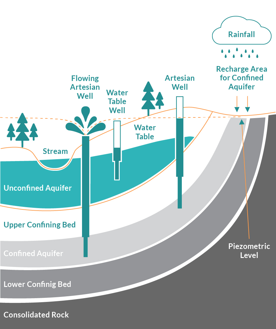
Figure 2. Diagram of an Aquifer System (Adapted from USGS, 2019)
Like surface water, groundwater resources can also be shared by different countries, and they are referred to as Transboundary Aquifers (TBAs). According to (IGRAC, 2021) there are now 468 globally identified transboundary aquifers and aquifer systems. Planning for TBAs is crucial towards identifying total abstraction rates, sources of pollution if present, multiple stakeholders shared across the countries, and the various socio-political and economic contexts that may affect its usage (see Tool C1.08 for information on Transboundary Diagnostic Analysis).